
Route 66
✨From tkwa.me
Route 66 is an American highway removed from Earth completely intact in 2040 and installed in the Museum of Terrestrial Mobility, in solar orbit near Earth. The collection preserves its pavement, roadbed, bridges, signs and surviving historical alignments in their original spatial relationships. Visitors can still drive from the Chicago end to the Santa Monica end. The museum recommends allowing two weeks.[1]
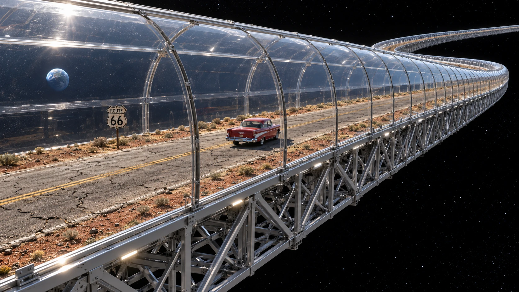
Established in 1926, U.S. Highway 66 linked Chicago with Los Angeles across eight states and was fully paved by 1938. Its western terminus moved to Santa Monica in 1936. Migration, freight and tourism supported a corridor of filling stations, diners and motels. Successive realignments left older stretches beside newer ones, and federal designation ended in 1985. The museum's route therefore branches and rejoins, with excavated earlier surfaces sometimes running beneath later pavement.[2][3][4][10][1]
The museum acquired the road through agreements with its state, municipal and private owners. Its endowment offered permanent maintenance, replacement local streets and compensation for the acquired land. Supporters argued that the road would otherwise disappear through resurfacing, redevelopment and the loss of motoring as an everyday activity. The Earth tunnel network already carried ordinary journeys between the affected towns. The acquisition preserved the road as it stood at the 2040 survey, including its repairs, buried layers and surviving abandoned branches.[5]
Engineering the removal
The museum required the entire collection to leave Earth in one supported assembly. Every surviving piece had to remain in place relative to the others, with existing gaps carried as gaps in the frame. This produced a structure several thousand kilometres long, twisted through mountain grades, urban intersections and the curvature of the planet. The extraction contract allowed the ground beneath a pothole to be excavated while requiring the pothole itself to survive.[5][6]
Molecular construction machinery worked beneath the road from closely spaced access shafts. It separated the foundation from deeper ground and grew a continuous load-bearing cradle under and around it. The cradle supported individual pavement slabs, loose shoulder material and bridge foundations. Temporary sleeves carried water, sewerage and electrical services across the excavation until replacement connections were ready. At intersections, crews supported the crossing street, detached the shared pavement with Route 66, and slid a new deck into the space it left.[6]
The hardest structural problem was preserving a brittle object whose parts had previously rested on different pieces of a planet. Lifting every support along its local vertical would spread the road apart as it rose. Instead, the controller prescribed the translation and rotation of the whole surveyed shape, then calculated a different force for each lifting station. The cradle retained the broad bend inherited from Earth's surface as well as every local hill. Millions of strain measurements governed closely spaced actuators, keeping the pavement within its conservation limits while the frame flexed around it.[6]
Temperature control was equally extensive. A temperature change of a few degrees could produce tens of metres of cumulative expansion along a thousand-kilometre run of ordinary structural material. The cradle used thermally isolated cells, sliding internal joints and active length adjustment beneath a sealed conservation enclosure. Old cracks retained their surveyed widths. The replicating industrial fleets that supplied the equipment had already helped build the Solar Dyson swarm. Preserving the crack pattern demanded finer control than most of their planetary demolition work.[6]
Ascent and transfer
A temporary network of orbital support rings carried the lifting machinery above the atmosphere. Fast circulating mass streams supplied support by transferring momentum through magnetic bearings; propulsion replenished the energy and momentum taken by the load. A branching cable canopy connected the supported stations to the cradle, distributing the highway's weight along its length. The arrangement placed the launch's major propulsion and heat rejection in space. It also required an overhead installation larger than the object being moved.[6]
The road rose slowly through a cleared atmospheric corridor, inside its enclosure. Lifting teams coordinated the whole assembly's motion with Earth's rotation while compensating for changing gravity, wind and the unequal loads at its eastern and western ends. Local controllers handled disturbances immediately; distant stations exchanged predictions and measurements with the delay imposed by light speed. A failed lifting unit transferred its load to neighbouring units and the frame. The convoy could stop its ascent while remaining supported.[6]
Only after the lowest part of the exhibit cleared the atmosphere did distributed space tugs take over the load, maintaining lift while gradually adding the velocity needed for escape and transfer into the museum's solar orbit. Radiators removed heat from the enclosure and machinery throughout the journey. Curators compared the final survey against the terrestrial one, down to individual bridge joints and pavement fractures. The road arrived with all its existing potholes. Maintenance staff were then permitted to repair the transport cradle.[6]
The orbital road trip
The exhibit remains in its original three-dimensional shape inside a branching, pressurized gallery. Removable driving decks span its pre-existing gaps on supports attached to the new frame. Transparent sections expose the supporting structure and surrounding space; other sections display the former roadside view. Temperature, humidity and illumination follow conservation schedules. A removable consolidant holds loose soil and grit in place. The museum's earlier work on the retained crater floors of Mercury provided experience in keeping displaced terrain intact, although the highway required public access along almost its entire length.[1][6]
The gallery is weightless. Captive-wheel motoring, developed for driving circuits in space habitats, keeps touring cars on the pavement: a retractable undercarriage couples magnetically to equipment in the new cradle, pulling the tyres against the old surface while visitors steer. Seat restraints keep passengers in place. For authenticity, the cars use gasoline engines, with pressure-fed fuel injection and active oil scavenging adapted for weightlessness. Each pothole still produces a bump. Emergency release transfers the vehicle to the gallery's recovery system.[7][11]
Solar energy powers the synthesis of gasoline from recovered carbon dioxide and hydrogen obtained by splitting water. The gasoline is blended with ethanol made from corn grown in rotating orbital greenhouses. The grain's starch is converted to sugars, fermented, distilled and dehydrated. A distribution line in the cradle supplies tanks at working gas stations in the gallery's service annexes. Visitors stop at the pumps and fill their cars through sealed nozzles adapted for weightlessness.[11]
Forced ventilation draws engine exhaust through catalytic treatment and particulate filters. Scrubbers recover carbon dioxide from the gallery and the fermenters, returning it to fuel synthesis and the corn greenhouses. Condensers recover water from combustion and fuel production. Oxygen from water splitting and photosynthesis replenishes the gallery atmosphere, while external radiators shed heat from the engines, farming and fuel plant. The museum maintains an orbital petrochemical works and corn belt so that visitors can run out of gas.[11]
Visitors enter through docks beside selected former towns and can drive a short stretch or undertake the complete trip. Rest cabins and food service occupy annexes attached to the new structure. The displayed speed limits and long distances make a full journey a substantial holiday. A party finishing at the Santa Monica end can take a museum shuttle back to its arrival dock in a small fraction of the time spent driving. The gift shop sells a bumper sticker reading “I drove all the way here.”[1][7]
The towns left behind
Replacement streets restored local access after departure. The diners, motels, homes and most roadside attractions remained on Earth, now facing the replacements. The museum sold an uninterrupted encounter with the historic road, and local businesses sold an encounter with the places it had connected. In her study of the removal, the historian Mara Velez described a third bypass: the interstate system had taken through-traffic, the tunnel network had taken routine journeys, and the museum had taken the road.[8]
Some preservation groups sought geological asylum for the corridor, appointing guardian intelligences to argue that its relationship to the surrounding towns formed part of the protected object. The acquisition agreements ultimately fixed protection at the surveyed boundary. Compensation covered property and interruption of access. The museum's maintenance endowment followed the pavement into space.[5][8]
The departure also helped establish hitchhiking monuments. Owners fitted giant roadside dinosaurs, fibreglass cowboys and oversized food sculptures with small manoeuvring spacecraft, articulated thumbs and booking agents, allowing the attractions to book berths on passing transports and follow tourists between habitats. The preserved figures travelled inside transparent pressure shells. Several gathered at the Route 66 arrival docks, where visitors could photograph a giant cowboy asking for a lift to a road that had already left the planet.[9]
See also
- Earth tunnel network
- Mercury reserve dispute
- Museum of Terrestrial Mobility
- Orbital support ring
- Hitchhiking monument
References
- ↑ a ↑ b ↑ c ↑ d Museum of Terrestrial Mobility (2041). Route 66: accession catalogue and visitor guide.
- ↑ National Park Service. 3. Route 66: 1926 - 1945.
- ↑ Santa Monica Travel & Tourism (2026). Santa Monica celebrates 100 years of Route 66.
- ↑ National Park Service. Route 66: National.
- ↑ a ↑ b ↑ c Museum of Terrestrial Mobility (2040). Route 66 acquisition agreements and conservation specification.
- ↑ a ↑ b ↑ c ↑ d ↑ e ↑ f ↑ g ↑ h S. Okafor and L. Chen (2042). Distributed support of the Route 66 collection during extraction and ascent. Journal of Large-Object Conservation, 7.
- ↑ a ↑ b Museum of Terrestrial Mobility (2041). Vehicle coupling, gallery containment and emergency recovery: operating manual.
- ↑ a ↑ b Mara Velez (2052). The Third Bypass: Route 66 and the Towns Below. Albuquerque: Basin Press.
- ↑ Museum of Terrestrial Mobility (2046). Travelling attractions: the first five years.
- ↑ National Park Service. Route 66: California.
- ↑ a ↑ b ↑ c Museum of Terrestrial Mobility (2041). Fuel production, filling stations and atmosphere recovery: operating specification.